
The officer of the watch task involves a lot of studies and concepts that must be understood in the best and fastest manner possible. The OOW promoted “second mate” in most merchant ships is in charge of developing the passage plan. While in the cruise ship industry, the chief officer usually carries out the job.
During the phase of gathering information, that is the initial step that the OOW in charge of planning a passage plan must do; other than the general information about the ports in which the ships will visit, the zone of confidence during all the trip must be checked with a high level of accuracy.
Understanding the symbol of CATZOC (Category of Zone of Confidence Data) is critical since it will determine the level of accuracy of the presented survey data.
If you are a cadet officer or an OOW that needs some refresh about this important concept, you are in the right place. In today’s article, we will take an in-depth overview of what is the zone of confidence in ECDIS, how to read them properly, and much more.
Page Contents
What is the zone of confidence on a chart?
CATZOC are symbols displayed in modern ECDIS and used during the appraisal phase of the passage plan by the OOW to determine the depth’s accuracy level.
CATZOC is based on position accuracy, depth accuracy, sea floor coverage area, and the survey method. The CATZOC also indicates the quality of the production process of the ENC and not simply the quality of hydrographic survey data.
It is important to understand that these values are approximate and indicate the lowest category of confidence that a survey or group of surveys can claim.
The data from surveys are often historical, and the categorization of accuracy may be based primarily on the reputation of the original surveying authority. The ECDIS operator should be aware that survey quality may be less than that indicated by the CATZOC level.
CATZOCs may also be downgraded at a later date via ENC updates, where survey quality is found to contain inaccuracies.
Explanations of the 6 CATZOC symbols
Now that we understand the importance of the CATZOC in the process of the appraisal of the passage plan, we will take a closer look at the meaning of each symbol that you will find on your ECDIS.
Category A1 CATZOC
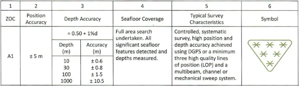
As we can see from the image above, the category A1 of the CATZOC is symbolized by a triangle with six stars inside.
Category A1 is the most accurate that you can find displayed on ECDIS. As explained in the article’s initial part, the 4 parameters determine the accuracy of the depth indicate.
To summarize the value of CATZOC category A1:
- Position Accuracy: +/- 5m
- Depth accuracy: 0.50+ 1%d (this means that for a depth of 10m, the accuracy will be +/-0.6, and for a depth of 100m will be +/- 1.5m.
- Seafloor Coverage: The survey of the areas has been fully undertaken, and all the features of the depths have been detected.
- Typical Survey Characteristics: The method used for the survey in the area where it is marked with category A1 is performed with DPGS and with sonar multibeam.
Category A2 CATZOC
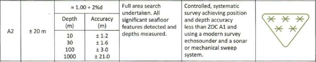
Going down in the table, in the second row, we find the category A2 of CATZOC.
Category A2 of CATZOC is indicated by the symbol of a triangle with five stars inside.
The value of A2 CATZOC are the following:
- Position Accuracy: +/- 20m
- Depth accuracy: 1+ 2%d (this means that for a depth of 10m, the accuracy will be +/-1.2, and for a depth of 100m will be +/-3.0m.
- Seafloor Coverage: In this case, the bottom survey has been performed, and all the significant seafloor features have been detected.
- Typical Survey Characteristics: The method used for the survey of this area has less accuracy than the ZOC A1, and usually, it is performed with a modern echo sounder and sonar.
Category B CATZOC
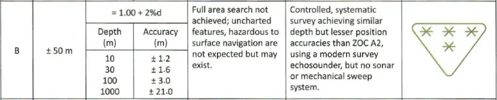
The next category that may face is category B. This category is represented by a triangle with 4 stars inside it.
The value of B CATZOC are the following:
- Position Accuracy: +/- 50m
- Depth accuracy: 1.00+ 2%d (this means that for a depth of 10m, the accuracy will be +/-1.2, and for a depth of 100m will be +/- 3.0m.
- Seafloor Coverage: The seafloor in category B of CATZOC may not be achieved. Anyway, there may not be any risk regarding hazards to the surface.
- Typical Survey Characteristics: In this case, the survey could be performed using modern echosounder instruments. Anyway, consider that the accuracy may be less than CATZOC A2.
Category C CATZOC
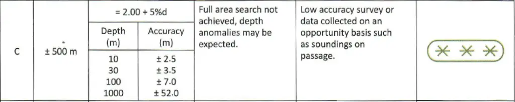
The fourth category that you might find in the ECDIS is category C. You might notice that you will face less accuracy proceeding in the list.
An ellipse symbolizes Category C of CATZOC with 3 stars inside.
The value of C CATZOC are the following:
- Position Accuracy: +/- 500m
- Depth accuracy: 2.00+ 5%d (this means that for a depth of 10m, the accuracy will be +/-2.5, and for a depth of 100m will be +/- 7.0m.
- Seafloor Coverage: The complete survey of the area may not be achieved, and depth anomalies may be expected.
- Typical Survey Characteristics: The accuracy of the survey adopted in category C of CATZOC is very low.
Category D CATZOC
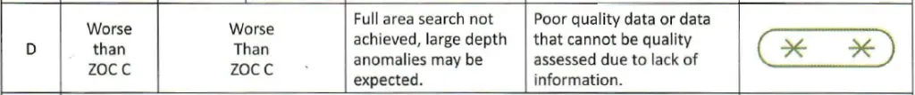
Category D of CATZOC is an area where particular attention must be done, as well as a further investigation by the officer in charge of the voyage passage plan.
An ellipse symbolizes category D of CATZOC with two stars inside.
The value of D CATZOC are the following:
- Position Accuracy: None, but worse than category C
- Depth accuracy: Also, in this case, the depth accuracy of CATZOC D is not specified, but it is assumed to be worse than category C.
- Seafloor Coverage: The complete survey of the area is not performed. Large anomalies of different values may be found.
- Typical Survey Characteristics: Poor quality of data and lack of information for the zone.
Category U CATZOC

CATZOC quality rated as ‘U’ for ‘Unassessed‘, ECDIS operators should investigate further.
Many ENCs have simply not been assessed for CATZOC because the Hydrographic Office producing the ENC has not been able to complete the task, and ‘Unassessed’ may not necessarily mean that the ENC is of poor accuracy.
ENCs may still be used in these cases, but a documented risk assessment may be necessary.
Why is CATZOC important?
Knowing the meaning of the zone of confidence in the ECDIS is a must for a qualified officer of the watch. It is particularly important because OOW must always guarantee safe navigation during the voyage.
For safe navigation, it is intended that the ship can sail from port A to port B without encountering any risk of grounding due to misleading information or interpretation of depth values from the OOW in charge.
Conclusion
ECDIS zone of confidence represents six parameters on which the level of accuracy of depth is determined. The CATZOC has been integrated into modern ECDIS to facilitate the work of the officer of the watch during the voyage planning, giving the ability to read with more velocity and with more valuable data an adequate level of accuracy from a specific area.
The zone of confidence in the ECDIS is significant, especially during the calculation of the UKC (Under keel clearance) required during the transit of shallow waters zones.