
Satellite Navigation is a method employing a Global Navigation Satellite System (GNSS) to accurately determine position and time anywhere on Earth.
Satellite Navigation receivers are currently used by both private individuals and businesses for positioning, locating, navigating, surveying, and determining the exact time in an ever-growing list of personal, leisure and commercial applications.
GPS (the full name of the system is: NAVigation System with Timing And Ranging Global Positioning System, NAVSTAR-GPS) is intended for both civilian and military use. The civilian signal SPS (Standard Positioning Service) can be used freely by the general public, while the military signal PPS (Precise Positioning Service) is available only to authorized government agencies.
When the first satellite was placed in orbit?
The first satellite was placed in orbit on February 22, 1978, and it is planned to have up to 32 operational satellites orbiting the Earth at an altitude of 20,180 km on 6 different orbital planes. The orbits are inclined at 55° to the equator, ensuring that at least 4 satellites are in radio communication with any point on the planet. Each satellite orbits the Earth in approximately 12 hours and has four atomic clocks onboard.
Basic principles of satellite navigation
One of the first basic concept for understanding how the satellite navigation work is to understand how can we measure the distance by applying the physic .
Let’s make an example:
Imagine during a thunderstorm that you wuold like to know how far away you are from a bolt of lightning. The distance can be established quite easily: distance = the time the lightning flash is perceived (start time) until the thunder is heard (stop time) multiplied by the speed of sound (approx. 330 m/s). The difference between the start and stop time is referred to as the signal travel time. In this case the signal is sound waves traveling through the air.
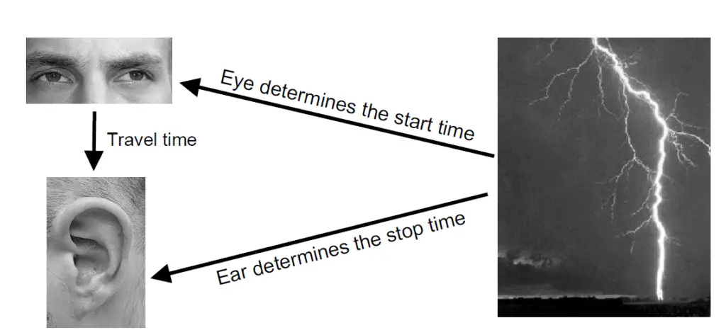
Satellite Navigation functions by the same principle. One calculates position by establishing the distance relative to reference satellites with a known position. In this case the distance is calculated from the travel time of radio waves transmitted from the satellites
HOW DOES GPS WORKS?
Satellite Navigation Systems all use the same basic principles to determine coordinates:
1.Satellites with a known position transmit a regular time signal.
2.Based on the measured travel time of the radio waves (electromagnetic signals travel through space at the speed of light c = 300’000km/s) the position of the receiver is calculated.
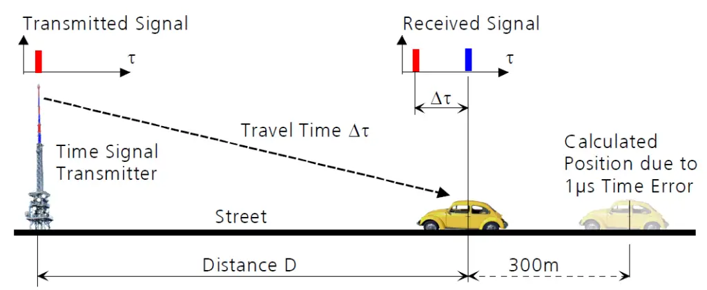
The distance D is calculated by multiplying the travel time by the velocity of light c.
Because the time of the clock onboard our car may not be exactly synchronized with the clock at the transmitter, there can be a discrepancy between the calculated and actual distance traveled.
In navigation this observed distance referenced to the local clock is referred to as pseudorange. In our example a travel time of one microsecond (1μs) generates a pseudorange of 300m.
We could solve the problem of local clock synchronization by outfitting our car with an exact atomic clock, but this would probably exceed our budget.
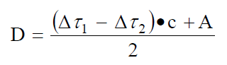
Another solution involves using a second synchronized time signal transmitter, for which the separation (A) to the first transmitter is known. By measuring both travel times it is possible to exactly establish the distance (D) despite having an imprecise onboard clock.
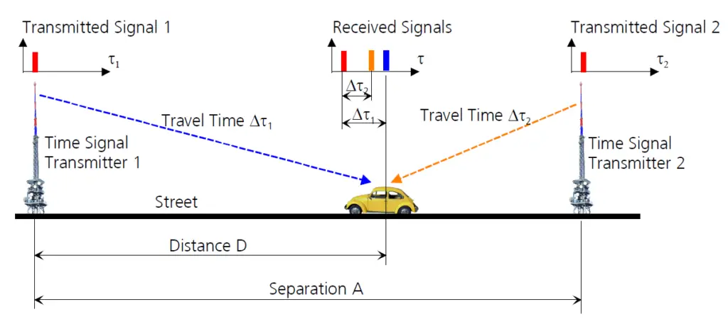
As we have seen, in order to exactly calculate the position and time along a line (by definition a line expands in one dimension) we require two time signal transmitters. From this we can draw the following conclusion: When an unsynchronized onboard clock is employed in calculating position, it is necessary that the number of time signal transmitters exceed the number of unknown dimensions by a value of one.
For example:
-On a plane (expansion in two dimensions) we need three time-signal transmitters.
-In three-dimensional space we need four time-signal transmitters.
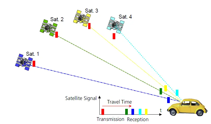
Satellite Navigation Systems use satellites as time-signal transmitters. Contact to at least four satellites (Figure below) is necessary in order to determine the three desired coordinates (Longitude, Latitude, Altitude) as well as the exact time. We explain this in more detail in the following articles.
That is all for this part of gps if like it let a comment or let me know on facebook page.
Read : Curiosity about Titanic